South America 2007 (Part 2)
Bolivia
(Click for map)20 Feb, it's a month since I left Canada for South America, and coincidentally the day we leave Peru for Bolivia. It all seems so fast, and I'm feeling a bit rushed. Maybe we're trying to do too much in the 3 months we have.
Add to that a persistent low-level diarrhoea, and I wasn't as cheerful or energetic as I should have been.
Anyway, we checked out of our hostal, grabbed a taxi and got down to the bus terminal at about 07.20. The bus was to leave at 08.00, and was a bit late, so we had plenty of time to grab breakfast in a restaurant in the terminal.
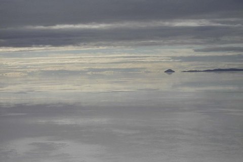
Out of Puno we drove, mostly along flat land along the edge of Lake Titicaca for quite a distance. That lake is certainly big; we didn't clear it until we got to the Bolivian border.
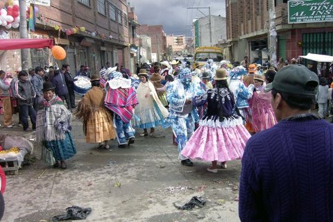
Carnivale, La Paz
The border town of Desaguadero was typical of border towns everywhere, crowded, bustling, grubby, lots of shops and stalls, touts and pickpockets. This place was also known for its money scams when crossing, but we fortunately didn't fall victim. In fact the crossing was quick and easy. We were stamped out of Peru (the official not even bothering to check my passport photo), walked across the river bridge, got stamped into Bolivia and back on the bus. We also changed some leftover sols into Bolivar, at a rate of 2.4 Boliviaros per Sol. That's 8 Boliviaros (Bs) per USD. So we had enough money to get us settled in La Paz. Watches changed to 1 hour ahead.
Instead of going through to La Paz, we sweet-talked the conductor to let us off about 70 km before La Paz, at a place called Tiwanaku. About 1.5 km off the road is the site of remains of pyramids and temples of the pre-Inca Tiahuanaco empire. This was one of the world's greatest and longest running empires, from about 100 BC to 1150 AD. There were a museum and 3 archaeological sites not far apart.
However, it was starting to rain as we got there, and the whole site was rather muddy and dismal. There wasn't a lot of eye-catching structure to see. I wasn't really impressed, and we walked back on the road after only an hour or so.
We caught a crowded mini-bus on to La Paz, putting our luggage on the roof and cramming ourselves inside.
The entry into La Paz, about 17.00, was quite spectacular. The mini-bus let us off on a high hilltop outside of the city centre, where we could get a panoramic view of the city below in the valley. Also, everywhere were crowds of people, some in costume and masks, dancing, carousing and spraying one another for the last day of Carnivale.
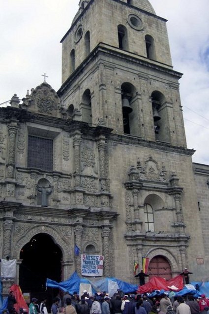
Demonstration, San Francisco
A taxi took us down along steep narrow streets into the centre and to the big old decrepit Hotel Torino, a reasonable room with bath.
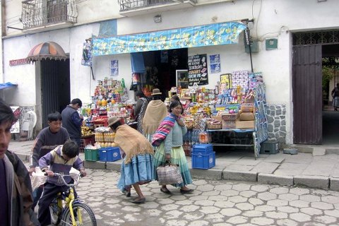
Later we went out to look around the plazas and other parts of the centre. La Paz is certainly grubbier and more run-down than cities in Ecuador or Peru. The streets are rough and in need of repair; buildings have a faded elegance look to them and are crumbling badly. It didn't seem like the place to spend too many days. Still I didn't mind it, and there was still a lot of Carnivale night life. In the courtyard outside the San Francisco Church, a lot of people were camping under plastic in the light rain; I later found out they were mostly miners and their families, protesting outside the church for better working conditions.
In the morning we took a walk around to San Francisco.The miners were conducting their demonstration, some standing on the sides of the church with arms stretched in a crucifixion pose. It must have been uncomfortable and I don't know how long they could keep it up. I gave them a thumb's up sign of encouragement.
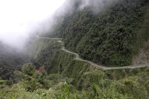
We walked up the hill a block or two, found a tour agent, and found information on things like biking to Coroico, trips to Colcataya and Sorata, bus connections to Sucre and Potosi, and expeditions through the Salar. We settled on the bike trip, the Highway of Death, for tomorrow. It would start at Lacumbre Mtn, drop about 2600 m in 47 km, and take 4.5 to 5 hours. The mini-bus would pick us up at the bottom in Santa Barbara, lunch and chance for a swim there, and back up to the city about 19.30. As trucks and other vehicles no longer use this road, it probably isn't as dangerous as it used to be.
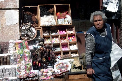
We were right near the Mercado de Hechiceria (Witches Market). It consisted of several shops along a couple of streets, selling a bewildering array of weird and wonderful potions, remedies and mystic concoctions. On display were dried llama fetuses, said to be used to protect homes from evil spirits.
A walk down the main street, took us through a tall-building commercial district to the Plaza del Estudiante, and to the very good Museo Tihuanaco, displaying many of the artefacts from the site we visited yesterday.
In the early afternoon I walked around to Parque Central. The park was gated up though, so I continued to the small Plaza Tejada Sorzano. There I sat on the grass for a while reading downloaded news articles on my PDA. Despite the traffic noise it was a sunny and pleasant interlude, until eventually city workers came along to cut the grass and moved me away.
Back at the Alexander Coffee Shop, armed with a cup of coffee and my PDA, I found that I could indeed get wi-fi here, and checked my bank transactions and a couple of sites.
Back with Herbert later, neither of us seemed very hungry. Strange, but I don't seem to have my usual ravenous appetite this trip; don't know why. So we settled on a light but delicious evening meal of hoummous-tahini, bread and tea at a Lebanese restaurant in the Hechiceria area. The place was owned by a Lebanese woman who has been here for years and evidently preferred to live in Bolivia rather than Lebanon.
Mercado de Hechiceria
The following day was "the world's most dangerous highway" by bike.
Part of the package was a breakfast that happened to be at our hotel restaurant; convenient. The mini-bus, mountain bikes on top, picked us up there about 08.00 or 08.30, a group of 6 or 8 people with a driver and a couple of guides. We drove up out of the city (How does anyone ever find their way around these labyrinths of streets?) and up to the pass at Lacumbre.
Issued with a bike (obviously), helmet, jacket and gloves, we made necessary adjustments and tire checks. We were off down the highway about 09.30 toward Coroico. One guide rode in front of the group and one behind, with the bus following all the way. We would stop periodically for pictures, refreshments and to regroup.
The first half or so of the 47 km ?? (conflicting statements of distance), was wide and paved. It was mostly fast coasting downhill but with a couple of gruelling (at this altitude) up-hills. The scenery was of course fabulous, immense valleys and partly cloud covered peaks. We descended through the cloud cover, cold at the top but gradually warming as we came to lower altitudes.
About half way, the road split. To the left went the new paved highway down to the river valley below Coroico. To the right was the old unpaved road, the "Highway of Death" that we were to descend. It was steep, rough, rocky, wet in places and narrow. However, without trucks on it now, only the mini-buses with the bike tours, it wasn't in my opinion all that dangerous any more. As long as you kept your eyes on the road and didn't veer off it was okay. Still the drop-offs were incredibly steep, making for breathtaking scenery. There was a story, maybe a UL, circulating that one foreigner had gone by bike on his own and had gone off the edge.
Death Highway
At one point we stopped for snacks and photos and a rest on a stretch of road with several very high waterfalls dropping onto the road. On starting again, we had to pass under the falls, failing to avoid a slight soaking. Other than that and a later creek crossing, it was quite dry and sunny.
We finished the bike trip at the village of Santa Barbera, below Coroico, after 14.30, a full 5 hours including lots of stops. Here we were in the heat of the jungle, totally a contrast to the high barren cold pass from which we started. The descent was overall fun, exhilarating and well worth it.
After the obligatory congratulations and high-fives, we loaded up the bikes, boarded the bus and drove up to and above Coroico, to a resort where we could use the showers and pool if desired, and have a big buffet late lunch. I showered off the sweat and road grime, and tucked into an immense meal of steak, rice, potatoes, cooked vegetables, salad, desserts etc.
About 17.00 we were ready to leave. The bus took us down through Coroico again, down to the river, across the bridge and up the new paved highway back to Lacumbre and La Paz. It was a long way with a huge ascent and slow winding road, so we didn't get back down-town until after 20.00.
After that big lunch we didn't feel like anything else at all to eat. Washing our dirty clothes took up the rest of the evening.
After the bike ride, Herbert felt like a day trip to Cocaltaya, which he embarked on about 08.00. I was feeling like a day off instead so stayed behind.
A strange thing happened as I walked out of the hotel and up to the pedestrian street Comercio,. I felt a bit of breathing stress and suddenly fainted. A local Peruvian who spoke English talked to me as I came to, saying it must be altitude (about 3500 m I think). A couple of cops took me to a pharmacy to get some altitude pills. I felt better presently and continued on to find breakfast and check out the main market district. The market was uphill a fair distance, and I stopped and rested a lot to be safe. I gradually got totally better, but it's still scary.
The markets are a bit unusual, seems like no big central market building with stalls, but rather lots of stalls and shops around the outsides of the city blocks.
From the markets I found the main bus terminal. Herbert and I had agreed to go to Sorata overnight tomorrow, return to La Paz, and take a night bus on Feb 25 to Sucre. I checked out bus companies and schedules and got the bus tickets to Sucre.
The day before leaving for Sucre, we took the bus to the hill town Sorata, a pleasant little place used as a base for treks and shorter walks.
A mini-bus got us from our street to the Cemeterio district, a busy bustling place next to the cemetery, from where some of these country buses leave. We got our tickets and were on the road before 08.00 in a cramped mini-bus.
The 3.5 hour bus trip took us past Lake Titicaca and up into the hills to its east. We had to cross a mountain pass in cloud and down the other side, along increasingly narrow, steep and wet roads.
Sorata
Sorata is a neat little town above a river, with a few streets and a plaza. I was taken aback by a statue of what looked remarkably like Adolph Hitler, but it was just some local dignitary. There's a peaceful market atmosphere and the weather was sunny and fine.
We walked down the long, steep and winding path to the river and across, where the Altai Oasis Hostal is. I wanted to do walking from here, so decided to stay in this hostal. It's quite a peaceful forest/farm setting, warmer than La Paz because it's lower. Herbert wanted to be more down-town, so walked back.
After a short rest, I set out in the afternoon for a substantial walk along the road in the direction of the next village San Pedro. I enjoyed beautiful weather, farms and hamlets, people going about their business, and very spectacular countryside. The road was far above a precipitous river gorge, with many valleys with inflowing creeks. Impressive mountain ridges and peaks filled the horizon.
I returned to near the hostal after about 3 hours walk. On a ridge overlooking the river was a group of people playing music, dancing and eating/drinking. It must have been a wedding ceremony. They welcomed me and I joined them for a few minutes. I could have stayed longer but it started to rain and I made my way back to the hostal, getting somewhat wet, despite my raincoat, in the process.
I seemed to be the only one around at the hostal, except for the young guy looking after it. Still, I was able to go over to the restaurant at 18.30 and get a great meal of Hungarian goulash, mashed potatoes and hot chocolate.
In the morning the rain had fortunately stopped. Up the wet and steep but not dangerous path to town before 08.00 to meet Herbert. He says there is a bus leaving at 8 back to La Paz. So we got tickets right away and were on the road again.
Just out of town, I heard a rumbling and saw a real live landslide in progress just ahead. Rocks and dirt cascaded onto the road, forcing the bus to make a rapid stop. It only covered part of the road, but we studied it for a while to see if any more was coming down before gingerly driving past it and onward. Landslides must be a common occurrence in the rain, but scary nonetheless.
We got back to La Paz about noon without further incident, arriving at the hilltop bus stop overlooking the city and transferring to a local bus got us down to the centre. There seems to be a lot of festive-type activity around the city today (Sunday), bands, parades, costumes, singing and dancing. Not sure what the occasion is.
The night bus to Sucre was somewhat routine, arriving in the Sucre bus terminal about 07.00, and a taxi got us to the Chacral Hotel, right down-town across from the main market. Rooms there were comfortable and handy.
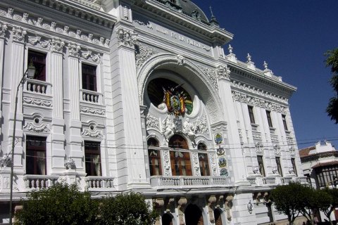
After a basic continental breakfast, lets get out and explore the city a bit. It sure isn't LaPaz. Sucre is much smaller, quieter, neater and prettier, really a very pleasant little place befitting its UNESCO heritage status. The streets are full of young people, probably mostly students, with a prominent promenade/café society. Much lower in altitude than La Paz, days are warm and sunny, but not sweaty hot.
Casa Libertad, Sucre
We looked around the down-town area, the architecturally perfect white Church of Santa Monica, the San Miguel Church with its wonderful Moorish ceilings, the elegant Plaza 25 de Mayo, and other sights around town. Later in the morning we walked up to and entered the Museum of Indigenous Art. It had great exhibits of textiles and other artefacts, and comprehensive ethnographic descriptions of the local cultures and their art and artisan works.
Up on a high point of the city, we had a nice spaghetti lunch and good views from the Café Mirador.
The afternoon was spent relaxing and looking around the market, a source of great fruit salad with yogurt.
La Plaza is an upstairs balcony pub overlooking the plaza, where we can be enjoy grande beers as we watch the crowds of teenagers hanging out in the plaza below.
On 27 Feb we decided to split up a while and do our own things. As Herbert looked around town and did textile shopping, I walked uphill out of town to the eucalypt-forested hills at the city's edge. It was somewhat of a climb, but I got into the forest and to good viewpoints over the city and surrounding countryside. The bush was even more tranquil and relaxing than the town.
I met Herbert at 12.30 for lunch. We wandered around looking for a lunch place and came across the Culture Cafe Berlin, a place the Germanic Herbert simply couldn't bypass. A nice lunch there filled us up with soup, bratkartoffel and egg or steak, and coffee or chocolate; but then on to the market for a fruit salad that really crammed us.
Later I went out to an internet cafe to do a little more email, some internet searches and download some news. Seems world stock markets are in a tizz because of Shanghai dropping 9%; hope my investments don't suffer too much. Herbert was suggesting, while in South America, we look into a possible trip to Antarctica. I checked, as much as I could, information on Antarctic sea trips from Ushuaia. They seem very expensive and they stop running in March; altogether not practicable or practical.
Last day of February, and we're off to Potosi today. We checked out our room before 08.00, and got a taxi to the bus terminal. The next bus was leaving for Potosi at 08.00, a small local bus for the 3.5 hour trip.
Through typical rugged altiplano country, scrub, cactus , farmland country and lots of climbs and descents, we arrived in Potosi late morning. We could tell in advance we were getting close because of the bare imposing mass of Cerro Rico ("Rich Mountain") towering over the city.
A taxi took us into the city from the bus to the Hostal Maria Victoria, a room in a nice place with a window view of the mountain.
Potosi is about 3800 m ASL, maybe just about the world's highest city. It is something of a contradiction, cold and bleak, but friendly and architecturally beautiful. Because of the silver mines on Cerro Ricco, it was one of the world's richest cities in the 16 and 17 centuries. It was notorious for the vast number of native slaves who died in the mines. The mines are still operating and conditions, though improved since the Spanish, are still pretty grim.
We explored around the narrow but character rich streets for an hour or so until the museums opened at 14.30. One of the most distinctive features of Potosi is the ubiquitous red clay tile roofs, giving the city its distinctive character.
With all that silver, they had to do something with it after mining. So first museum of the day is the Casa Nacional de Modena, where since the 16 century the silver was moulded onto ingots or minted into coins. Production has ceased and it became a museum in the 20 century. In addition to its architectural beauty, a guided tour of the Casa was fascinating and extremely informative. It took us through the history of the mint, from the earliest coins to the present. Curiously, the 5 Bs coin is now minted in Winnipeg. Particularly intriguing were the huge wooden mule-driven gear mills that milled the silver into flat strips.
After the mint, we took in the nearby Museo Mirador San Francisco, a Franciscan convent that is still active. It's another architectural marvel. A personal guided tour took us through the courtyard, chapel, catacombs, and up onto the roof for unbeatable views over the convent and the city and surrounds. WOW, where's Quasimodo?
Dinner was at another architectural marvel, a restaurant and theatre combined, beautifully restored but no theatre on tonight.
It's cool at night. The multi-layers of blankets on the bed weigh a ton, but it's comfortable enough and I slept well.
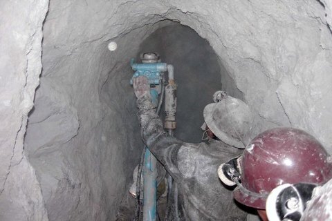
Next day was the reason for coming to Potosi, a tour of the mines on Cerro Rico. We signed up with a tour operator and got in a mini-bus to go up towards the mountain above the city. On the way we stopped at a market to buy coca leaves, soft drinks and cigarettes as gifts for the miners. We could have also bought dynamite for them if we wanted, but that's a bit heavy for me. At a shop near the mine we were decked out in boots, jacket, pants and light for mine entry, and up to the mine entrance about 10.00.
Cerro Rico
This is not your usual tourist mine tour. We walk right into the underground mine for some distance along the rail lines through the narrow horizontal muddy shafts, and right up to the work faces. Some areas were accessible only by ladders. We see the miners loading wheelbarrows and ore carts with the ore, pushing the carts along the shafts (careful, they have no brakes), drilling with incredibly heavy jack hammers, planting charges of dynamite or ammonium nitrate, and experiencing the concussion of the blasts. It's all very claustrophobic, wet, muddy, dusty, hot in places, and hard work. Conditions are horrible by our standards, and many accidents and deaths occur each year (though of course lots fewer than when the Spanish were running it).
A final stop underground was at a deity icon in a side passage, a devil figure with an enormous penis (part fertility and part machismo). Apparently they worship God above ground and the devil below.
The whole tour lasted 3 or 4 hours, was physically (especially at 3100 m altitude) and mentally intense, and one of the more worthwhile activities I'd done on this trip to date.
In the afternoon we split up for a while. I walked the couple of miles or so down to the bus station and got bus tickets for tomorrow 08.00 to Tupiza, about 8 hours south not far from the Argentine border. It's supposed to be quite pleasant and scenic around there.
I still feel the altitude here, must stop and catch my breath quite often. On the way back home I saw a group of women sweeping the street just ahead, making a cloud of dust. I thought I'd hold my breath as I walked past, and had very quickly to sit down to avoid passing out.
In the morning we were up before 07.00 and at the bus terminal by about 07.15. The O'Global bus to take us south to Tupiza is a bit rough looking, not the camas or semi-camas we're used to. It seems all the buses on this route are like that. Probably says something about the roughness of the road.
Toward Tupiza, the road was indeed quite taxing, mostly unpaved, with lots of road works in progress, and much of it winding along river beds and climbing/descending through hills. It took close to 10 hours. But the further south we went, the more ruggedly beautiful the scenery became. This is the part of Bolivia where Butch Cassidy and Sundance Kid met their end, and it's real bad-lands country. Fantastic rock formations, dry gullies and cactus dominated the landscape. It rained much of the way, a seeming contradiction in this arid land.
Into Tupiza about 18.00, a tout found us and took us to the Hotel Mitru, where we got a basic but comfortable room. TV with CNN is always welcome. And the hotel had a swimming pool, which we eagerly tried before bed.
Vale de los Machos
In keeping with its setting, the small town of Tupiza does have a wild-west atmosphere; dust, wide empty streets and rocky surroundings. It's about 3000 m high, and considerably warmer than Potosi.
In the evening we talked to the tout, also a tour guy, and were talked into doing a 5-day/4 night tour with him day after tomorrow. It would take us through many of the sights of south west Bolivia, including Lago Verde, Lago Blanco, the Salar de Uyuni, and thence on into Chile and San Pedro de Atacama. It seemed like good value, and would get us quite a distance.
3 March is the day to explore around Tupiza. After a good big complimentary buffet breakfast, Herbert opted for a 3 hour car tour around many of the sights near the town. I like walking, so just took off south from down-town, starting a bit after 09.00.
I passed a large market near the edge of town,and climbed a small hill to get a view of where to go. Seeing a road winding through the hills far to the south, I struck off in that direction.
The walk took me through rocky hills and scrub/cactus country. Resting just beyond a pass, I was overtaken by travellers on a horse tour. They were headed up a river valley to the Canyon del Duenda, so I walked that way too. It was a small cleft between giant rocks, scenic but blocked beyond there.
I met a lone Dutch woman trekking (she doesn't like horses), and she advised me where to go to see some of the other natural landmarks in the area. Following her instructions, I walked back part of the way I came, then turned off the road near a cemetery, up a small path and a disused road, past a garbage dump, and on a road in the direction of the town. I came to a side track going up to the left, which took me into some of the most spectacular bad-lands country I'd seen yet.
First was the Puerto del Diablo, a vertical "breadknife" formation, with a gap through which I passed. Then to the "Valle de los Machos", maybe named for it's numerous towering columns reminiscent of phalluses. Much of the landscape here was towering sharp spires and similar formation. Finally I came to the "Canon del Inca", a small pleasant box canyon from which I could go no farther.
Back to the road, it was only a half hour or so back to town. I'd been gone about 6 hours or so, and was hot and tired. A hamburger and fries and a litre Coke revived me and got me back to the hotel for a shower and rest.
4 March is the start of our 5 day tour of SW Bolivia and into Chile. After breakfast we met up with the tour driver/guide (Spanish only, hopefully no problems), and organised our luggage with him on the Land Cruiser. Joining us were James (British), Isabela (Spanish) and Francesca (Italian). We were 5 people plus the driver and a cook (maybe his wife). Start was shortly after 09.00.
This was going to be a great trip, some of the most remote and high-impact scenery in all of Bolivia, and maybe all of SA. We never drove more than an hour or two at a time; always something to stop for and admire/photograph.
Sillar
From Tupiza we struck out along a dry riverbed (all the roads would be remote dirt or rocky tracks, not suitable for cars), past the steep red rock formations called the Palala. From there, maybe a half hour or so later, we came through the Sillar (Valley of the Moon), even more striking red rock peaks and craters; there we stopped on the hills above to take photos.
Farther on, through rolling semi-desert, scrub and tuft-grass country, we passed the small mining villages of Nzerentino and Chilcobioja. They didn't look like much, mud-brick villages with a few shafts around, but they are said to be very lucrative for the villagers.
There's llamas everywhere, owned by local people, some decked out in cloth decorations on their ears, grazing on the sparse vegetation. We stopped near a herd of them for lunch (sandwiches, tamales, salad and fruit). We were delighted by the antics of an hours-old baby llama and its mother (its age evident from the fresh placenta on the ground nearby).
By late afternoon we had passed the village of San Pablo de Lipez, and came to San Antonio de Lipez, where we stopped for the night about 17.30. Accommodation was in a dormitory that the villagers rent to the tour group, and cooking was by our cook in a small kitchen. Somebody in our group found a supply of beer, greatly enjoyed by all.
This is a really remote place. There's nothing around except the semi-desert and hills. Before the dinner, a group of the local kids challenged some of the travellers (there's a few jeep-loads of us here) to a game of soccer on the local pitch, good fun but tiring at this height.
San Antonio de Lipez
Dinner was a nice combination of meat stir-fry, mashed potatoes, bread, vegetables and salad.
This place is about 4200 m high. The altitude still affects us a bit; it gets dark and cools off fast. So early to bed. It wasn't that cold in the dorm, and we had lots of blankets, so slept well.
We were up about 05.00 to have breakfast early because it's going to be a 10 hour-plus driving day. The sun was just rising as we started off.
We hadn't gone far when we came upon a Land Cruiser stopped on the track with electrical engine trouble. The Bolivian occupants had broken down the night before and had to spend the night in the vehicle, probably cold and uncomfortable. Our driver, a good mechanic, had them started up within minutes and we were on our way.
Next stop was the ruins of a colonial village, little remaining but the mud-brick walls of buildings and several viscachas (Remember them at Machu Piccu?) running around. We wondered why a village would be here, and were advised that this was once a gold and silver mining area
From there, we came to and stopped at the picturesque salt lake of Morejon. There are many salt or mineral lakes on the route, some with borax extraction industries supporting local populations.
On through more semi-desert and the twin villages of Quentena Chico and Quentena Grande; curiously the Chico village is the bigger, the Grande one merely being the first to be established. Hard to see what they do here, but there are lots of llamas around, there is a small military base and maybe some mineral extraction.
Following were more stark and beautiful lakes, including Kollpa, Chalviri and Aguas Calientes. All of these are mineral or salt lakes. A.C. of course was a thermal lake with a hot pool and a village built on the edge, good for a half hour spa swim and a lunch there.
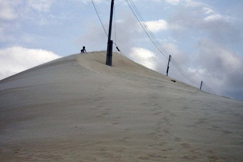
Shortly after is the Desierto de Dali, a sand dune area with strange looking rock formations protruding from the sand. The weirdness must have inspired the name.
We passed near the south-west corner of the country, and the Chilean border, in the shadow of the giant Licancabur Volcano. Here were the two lakes Laguna Blanca and Laguna Verde, the names coming from the colour of the waters. Laguna Verde had an especially beautiful shade of green, worthy of a few photos.
After backtracking to Aguas Calientes, we struck north to Geisers Sol de Manana, a small geothermal area with fumaroles, boiling mud holes, geysers and the usual sulphurous smell. We stopped there for photos, but Herbert advised me that we'd see better in Chile. The altitude here was 5000 m, the highest we'd been so far in the whole of our trip.
It was after 17.00 as we came to Lago Colorada, the famous red lake with its flamingo flocks. A small village near the lake looked to have been built solely for the purpose of tour group accommodation and it's here we stopped for the night. We'd been on the road for over 10 hours, and I for one was getting a bit tired.
Accommodation was dormitory as last night, and a good chicken dinner was prepared by our very competent chef. Our shout for the beer tonight, and I found a small shop where I could get a dozen Argentine beer.
The third day of the expedition was not as long a distance as the second, but because the pace was more relaxed, we stopped longer in each place and the total time wasn't much less. We still were up by 06.00 and on the road before 07.00.
First stop was Lago Colorada itself to see and photograph the large numbers of pink flamingoes. With the backdrop of the morning sun, they did make a good picture. The colour of the birds is said to come from eating the red algae in the lake, but I don't necessarily believe that.
Arbol de Piedra
A bit further was the Arbol de Piedra, another Dali-like series of rock outcrops protruding from the desert. It got its name from one outcrop that looks a bit like a rock tree.
Next was a chain of 5 lakes with varying degrees of saltiness (and of borax extraction industry) and scenic quality. We stopped at some of them, but time and repetitiveness precluded stops at every one. Some had flamingoes like at L. Colarada.
On past Ollague volcano we skirted the edge of the large but not very exciting Salar de Chiguana. Maybe we're just getting salar'ed out by now.
The village of San Juan, south of Salar de Uyuni, was I think where we were originally going to spend the night. But the group decided to spend the extra 80 Bs each to stay in a real salt hotel, at Atuilcha on the edge of the Salar de Uyuni. We arrived at Atuilcha after 17.00, another long and tiring day.
The salt hotel is I guess a bit unique, although there are a few of them springing up around the lake edge. Like ice hotels in northern countries, they seem to cater to the novelty market. The floors and walls are built of salt bricks and salt mortar, and the roof, doors, windows, banos, electricals etc. are of conventional materials. Staying in one is not much different to any other hotel. However, we did get a good meal there, of soup, llama steak, quinoa (a cereal) and vegetables. The llama was nicely done in a spicy coating, and didn't taste any different to any other meat.
Next day is the big day for the Salar de Uyuni, the world's biggest salt plain. We weren't sure whether we would be able to cross it at all, with reports of rain enough to flood most of it. But ours and other drivers decided to take it on.
Salar de Uyunyi
About a 07.00 start again; our convoy of 5 Land Cruisers started out for a short distance on a raised road built over the lake flats. Then off the road and straight across the lake. The water depth varied up to about 4 inches.
When on the lake with the water all around, and no waves, is quite an incredible feeling. The far distant shore, with its hills and complex cloud formations reflected in the water, have a look something of a surrealistic Mandelbrot Set.
Driving across the water is an experience in itself. The vehicles send up big plumes of water from the wheels like a speedboat; you can see other vehicles from a long way off.
We drove for an hour or so to get to Incahuasi Island, a 1 sq km island covered with coral rocks and large cactus (one of which is 1200 years old). We spent an hour there walking over and around the island. It had, despite all the tourists, a peaceful, tranquil atmosphere.
From the island we had to strike out for a point on the shore near Uyuni, a drive of 3 hours or so across the lake.
The salt plays havoc with the vehicles. We came across one that had stalled in the lake the night before, the occupants having had to sleep there. Our own had starting difficulties on the island, and then stalled later a couple of times on the lake itself; maybe salt in the electricals or something. Then when we were going again, salt kept clogging up the radiator and heating the motor. We had to use up a lot of fresh water to wash the radiator several times, and try to shield it from spray.
What an experience!
A late lunch was at another salt hotel near the Uyuni exit, then our salt-encrusted vehicle was off the lake by nearly 15.00.
Herbert and I were supposed to be in Uyuni to meet a 16.00 connection, with another tour group, on to Chile. We got there to the drab and uninspiring town by 15.45. Our connection was changed to 18.00, so we had some time to look around town, change leftover money into Chilean Pesos, rest and read.
The ride to Chile, another Land Cruiser, didn't leave until nearly 19.00, with 3 other passengers. It wasn't as nice as the other tour group, just drive on through and get A to B. We drove into the night, on good dirt roads, and got to the village of Altoa about 21.30 where we spent the night. A simple dinner, a cold shower, and I was in bed in the dorm by 22.20; a long and exhausting day.
The driver had said to get up at 04.00 to leave right away. But he didn't show himself until about 05.30, and we didn't get rolling until nearly 06.00.
The roads got progressively rougher, more like the previous days, as we drove south. It was sunny but previous rain made lots of splashing in water holes. We passed Laguna Colorado and made for the Chile border near Laguna Blanca and Licanbur Volcano where we were earlier in the tour. Our driver dropped us at a small outpost near the border about 13.00, where we had a small lunch and got a bus (part of the package) to take us across the border and to San Pedro de Atacama.
The border crossing was routine, except that the Bolivians wanted $2 as some kind of exit duty.
Overall, I liked my 16 days in Bolivia; it was scenic, spectacular, lots of surprises, nice people, and very affordable.
Chile
(Click for Chile, Argentina, Uruguay and Paraguay map)
It's 8 March and we're out of Bolivia.
As soon as we got to Chile we almost immediately got on to a good paved road. It felt almost weird, not having seen pavement for a week or more. We descended a long way down to the Salar de Atacama, and to the town of San Pedro. While still at about 2500 m altitude, we were well and truly out of the Altiplano, and it was warm and dry.
Our bus dropped Herbert and me down-town, and we started to look for a hostal. The first two were full, but the third, Pensione Rayko, had good basic rooms.
We did laundry and rested before starting out to look around town. It's a hot dry dusty place, but not unpleasant, with lots of tour offices, souvenir shops and tourist restaurants. Food looks 2 or 3 times as costly as in Bolivia.
After some looking around and a lunch at a local restaurant, I withdrew money from a bank machine. We checked out activities around here, and booked a tour to Vale de la Luna for tomorrow at 16.00.
Boy are the stars ever bright out here in the desert!
SPDA is an easy place to relax in and not do very much. It's a small enough town to walk around in and out of, the weather is warm, dry and sunny, and the whole place has an unhurried pace. There are no big buildings; nearly everything is mud-brick huts.
Breakfast is usually a trip to a small store to buy some bread rolls and sliced ham. That and some fruit will keep us going till mid afternoon. Then there are food stalls near the bus places that give a plate of chicken or fish, rice or quinoa, salad and coke. Evening meal is usually something light.
We booked a bus for 11 March at 08.50 for the 24 hour trip to Santiago. Then at 16.00 we met up for the bus tour to Vale de la Luna and other points near town. The medium size bus had 20 or so people.
First stop was a photo point near the highway, I think called Cordierra Atacama. It was a rugged and rocky land mass with visually stunning formations, and views over the Salar de Atacama and to the mountains toward and in Bolivia.
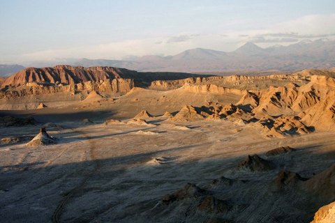
Next we went to another valley, called alternatively Vale de Marte (Mars) or Vale de Muerto (death). From the top of the valley we did a half-hour trek, along what was once the main road, to the bottom of the valley where the bus picked us up. Again it was a rugged and beautiful landscape.
Then to the main attraction, the Vale de la Luna. This part of the trip was divided into 3 parts. First we paid the entry fee and did a half hour exploratory walk through a rugged canyon area, full of salty rocks and narrow squeezes. The whole valley is full of salt, which inhibits life and gives it its lunar appearance. Apparently it virtually never rains here, so the salt doesn't get washed away.
Then back in the bus and to another area of the VDLL. A short walk took us to a rock formation called the Three Marias; one holding a baby, one praying and one fallen down. You have to use a bit of imagination but they're there.
Vale de la Luna
Finally, to the centre of the park, where we leave the bus and walk up to the top of a ridge to see the sun set over the main valley of the park. What a panorama; vast rock formations casting long shadows as the sun sets, and views all the way to Lucumbre in Bolivia. We stayed up until the sun had set, then down to the bus while we could still see, and back to town. All in all, the tour was compact, intense and well worth it.
Next days a relax not-do-much day. After breakfast and catching up on some computer things, I decided to go for a walk out to the north of town. I took a back road, out past houses, thorn hedges, fields and desert, all tranquil and invigorating.
About 3 km north of town is the Pukara de Quitor, a Inca-period fortress on the top of a bluff. It had been stormed and taken by the Spanish, and has been recently restored. I walked up past the ruins of the village and up a long series of switchbacks to the top. There's not a lot up there except a couple of monuments, but good views over the countryside and town.
Back in town later in the day, more relaxing and doing laundry, and a little more internet. I'm getting a bit pissed off with the internet services; yesterday I had trouble with recognising my memory stick and uploading pictures. Today I couldn't seem to download and save emails on my SD card. Always something crazy going on.
11 March is the day for that long bus ride to Santiago, so down to the bus place to leave at 08.50.
Northern Chile is mostly desert, and that's what we drove through nearly all the way to Santiago. The countryside is mostly barren hills and stony plains. As we approached Antofagasta we passed giant open-pit mines, presumably tapping some of those immense copper deposits. Antofagasta itself seems mainly an industrial city, serving the mining and construction sectors.
Here we briefly hit the coast, then back inland for more desert hills. It wasn't until nearly dark that we again came to the seashore and a rocky coastline. After the usual quality snooze, we came in to Santiago just before 09.00 and alighted at the bus place, slightly to the west of down-town.
The metro is near the bus place but it had big lines of people so we opted for a taxi down-town. It dropped us at the Hotel Nuevo, a run-down but friendly place.
First item was to check up on Navimag ships from Puerto Montt to Puerto Natales. A quick phone call told us that the next boat boat was full, no spaces until March 26, too late for us. That was a bit of a shock; how do we get to PN, or not go at all? I really wanted to do some trekking at Torres de Paine. Must think about it.
I had to walk a few blocks to the Brazil Consulate to get a Brazil visa, arriving there about 11.00 (their hours are 10.00 to 13.00). Besides the normal paperwork I had to go to a bank and pay for the visa. I had trouble finding the bank, then there was an hours-long queue. Another girl that was also getting a visa helped me out; we found another bank together, paid the visa fees, and back to the consulate just before closing. I have to pick up my visa on Thursday.
Near the consulate I was close to Cerro Santa Lucia, a rocky outcrop and park close to the centre of the city. I took a walk up the many steps and through a park-like setting, discovering good views over the city.
Santiago is a big, modern, developed city, somewhat polluted but otherwise clean and pretty. There are an infinite number of stores and restaurants of all types. Some of the shopping arcades could as easily be in Sydney or wherever.
In the morning Herbert found the Goethe Institute, a bit of Germany In Santiago. So we had both breakfast and lunch there, all good and reasonably priced.
We found the Lan Chile office and tried to find out about flights to Puerto Natales (there are none, all go to Punta Arenas and then bus to PN). We decided against that so we will not be going south. Unfortunately that means no Torres de Paine, at least this time. We might leave for Argentina in a short time.
We took in the Museo Chileno de Arte Pre-Columbiano in the morning. This was a fascinating place, very well-presented exhibits of good quality artefacts and artwork from various civilisations throughout Central and South America. Very well worth the 2000 peso admission.
In the afternoon I took a long walk east through the Bellavista, Providencia and Las Condes parts of the city. These are modern, built-up and wealthy areas of Santiago, so quite a pretty walk. Lots of nice restaurants and hotels, etc., and even into the swank embassy district. I was looking for the Varig office to check on flight promos in Brazil, but the 2 addresses I had didn't work so no luck.
There's lots of activity on the pedestrian streets in the evening, including an anti-Iraq-war demo in the Plaza.
14 March is a sort of r&r day. It's my birthday so no big stress.
In the morning we slept in a little, then to the nearest Tur-Bus office to book a bus to the Argentine border and Mendoza, about 13.30 tomorrow.
From there I walked through the centre, across the main east-west street of Alameda, past the university, and explored the south part of down-town. It wasn't as swish as the centre and had more of a bohemian atmosphere, lots of young people and furniture shops. I was intrigued by a large church/cathedral, built of poorly moulded concrete and looking much like a grain elevator or something.
Toward dinner time we wandered around the Plaza de Armes and selected a terrace restaurant for a meal and a few beer (for the birthday). It was quite pleasant people-watching, eating/drinking and discussing the bigger issues of life.
Next day was our last in Chile. We will go on the bus about 13.45 for the Argentine border.
A light breakfast, then to the Brazil consulate at 10.00 to get my passport. But they said come back at 10.30, so a bit more time to kill. Promptly at 10.30 I got my passport with Brazil visa. Back at the room we checked out by noon. We took our packs and walked over to Cal y Canto metro station to take the tube train to the bus terminal. The metro worked quite well; cheap, fast and not crowded at that time of day. One change of train got us to the bus place by 13.00 or so.
The bus was about a 7 hour trip with border stop etc. As we left Santiago north and east, we quickly re-entered semi-desert country and made the long climb up the Cordierra Andes. Scenery was rugged, but unlike Bolivia the highway was good paved road. Unfortunately, it was too cloudy to see Aconcagua. We weren't much more than a week in Chile; the aborted plans for the boat trip to Puerto Natales meant I didn't see as much of this country as I'd hoped.
Argentina
It's 15 March. The border, a big drive-in barn-like structure to the east of the pass, was quick and easy with both stamp-out and stamp-in facilities. We were now in Argentina. A few more hours got us down out of the foothills, onto the dry plain, and into the city of Mendosa.
We changed money at the bus place in Mendosa. A tout at the bus took us to the Hostel Punto Urbano in Mendosa, a nice room in a modern building (what a difference to the Santiago one!) with friendly staff.
Arturio's
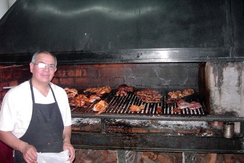
Late dinner at Arturio's restaurant, one of those Argentinian meat barbecue restaurants. I had a parilla meal and litre beer. They bring out a little barbecue grill to my table with steak, chops, sausage, chicken, blood sausage, offal and whatever; waaaay too much meat. With meals like that, you can really tell you're in Argentina.
It rained a lot overnight and into the morning. So after sleeping in and having the hotel continental breakfast, we donned rain gear and walked around town. We booked a bus to Buenos Aires for Sun night 18 March at 18.15, to arrive 19 March at 08.30.
It was too wet to go far, so we explored the down-town streets, plazas and shops, had lazagna lunches in the market, and generally a relaxing day. I bought a bottle of local Mendoza Merlot to try later; the wines here are cheap and good.
A walk east to some parkland, and then north to another park, passed the time but neither parks were that great. I might go tomorrow to the big park to the SW of town.
Wasn't that hungry this evening (a bit of stomach upset maybe, and I certainly didn't need more meat) so no dinner. I just nibbled on some nuts and a banana.
Next day Herbert noted that there was a Saturday artesan market in Plaza Espana, so we walked the 10 blocks or so to check it out. There was a market with several craft stalls starting up there, but it wasn't that unique or exciting. Nearby though was a motorcycle club rally; lots of bikers with their fancy hogs, insignia, etc. You must have started something all those years ago, Ernesto.
I started walking west, via Plaza Indepencia, to the big (550 ha) Parque San Martin. It's one of those multi-purpose parks with a variety of landscapes and facilities, including botanical gardens, lots of trees, undeveloped desert, zoo, stadium, horse club, golf course, theatre and a look-out hill. I spent a good couple of hours wandering around the park, very relaxing, despite the distances, and enjoyable. The Cerro de la Gloria afforded great views over the city and toward the Cordierra Andes.
Also I found a big Carrefour (French) supermarket so stopped there to have a look. It had pretty much what you'd expect in any supermarket anywhere. Interesting that lomo (beef fillet) is 17 pesos (about USD 3-4) per kilo.
Near the supermarket is the old train station, in a similar state of ghostly dereliction and disuse to the rest of the line going into Chile.
The cars on the streets are mostly European, and mostly older ones, heavily weighted in favour of Renaults and Peugeots and the like. Funny that there are virtually no Japanese cars; I couldn't find a Toyota or Nissan to save my life (later I did see a small number of Jap cars, and even a dealer).
In the evening, back to Arturios Restaurant for another carnivore meal. We had good beef ribs, sausages, potatoes, salad, bread and a beer.
After about 3 days in Mendosa we move on to Buenos Aires. So no big activities on our last day, just a little walking around, relaxing, reading and some internet activity, and organising our gear for the bus tonight. We checked out of the room at 11.00 but left our luggage at the hotel and hung around there part of the time. In late morning/early afternoon I took a walk to the park on the south side of town; pretty with lots of greenery and some big public buildings, but not really spectacular. It was a warm, sunny and pleasant day, made me sorry to leave this amiable and easygoing city.
We got a taxi to the bus place in time for the 18.15 departure. As we rode east into the night through dry flat pampas country, I couldn't help notice the large number of wineries and grape fields. This is really big wine country.
A really good hot meal came with the bus trip, a pleasant surprise. Argentinian buses are really good. I slept as well as one can on a bus.
19 March, and Buenos Aires is some big city. It took about 3 hours to get through it to the bus terminal, making a couple of stops and going right through down-town. Traffic is horrific and we weren't off the bus until after 10.00.
By the time we checked onward bus details and got a taxi (with a fair bit of getting lost), it was after 11.0 by the time we got a hotel. We got a room at the Hotel Maipu right in the centre, maybe a bit noisy but cheap.
La Boca, Buenos Aires
We had the whole afternoon to explore around town. First was a short walk to the Av 09 de Julio and a look at the famous and historical Teatro Cólon, at the time undergoing restoration work. Then down the street to the Obelisk, sort of a mini Washington Monument. Then along Roque s Pena to Plaza de Mayo, with its Cathedral (not unlike others I've seen) and the usual array of buildings & statues.
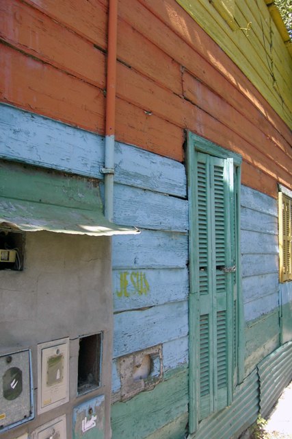
From there, we decided to get a city bus out to La Boca, a river-front district that is now home to a bohemian, arty-crafty society. Herbert had been there before, but was shocked at how developed, commercialised and touristy it had become. It was reminiscent of gentrified waterfront developments in any city. Some of the brightly coloured wood/corrugated iron buildings and art sale stands were still there, but the place was now full of souvenir shops and terrace restaurants, heavy on the tango theme. It also makes one wonder what they would do without Eva Peron, Maradonna and Ché.
Back down-town by bus, we walked along the waterfront to the ferry terminal. After getting info, we booked a ferry across the Rio Plate to La Colonia in Uruguay, for 09.00 Mar 21, a 3 hour trip.
We got CNN on the TV, so were able to catch up on news. The room was noisy at night but I put in earplugs and slept OK.
Our full day in BA was a day for general walking and exploration. We started off walking along the pedestrian street Florida, lots of upmarket boutiques and restaurants, and a Mcdonalds or Burger King every block.
From there we wandered through the San Telmo and Monserrat districts. They were meant to be older, picturesque and architecturally distinct parts of the city. But they weren't much more different or exciting than other areas.
While Herbert stayed around the antique shops of San Telmo, I went seaward to the big Costanera Sur nature reserve on the edge of the Rio Plata (or seashore; whatever because the river is too wide to see across). With paths along seashore, forest, pampas grass and swamp, it's the nearest I'd get to bush around here. The walk was hot but enjoyable.
Lunch for me was a big plain “hamburgesa†near the park. In the afternoon I continued along Av del Libertador out past the railway yards to the Recoleta Cemetery. By the railway yards was a sort of arts centre with several cool looking sculptures made up of welded scrap metal; things like old aircraft, human figures, birds etc.; neat. The cemetery was itself interesting, full of big opulent crypts for the well-to-do, about a century old. It's now a museum. Most of the crypts are very elaborate and well maintained, but some have become derelict.
Back to the room by 16.30, after a long but good walk.
On 21 March we're going by ferry over to La Colonia in Uruguay. We'll plan to be in Uruguay about 3 days. Up at 07.00, left most of our gear in the hostel, and walked toward the ferry terminal.
Check-in was like in an airport, passports, security etc. We weren't on the boat until after 09.00, but they bumped us up to a fast boat, so it would only take an hour to get across.
Uruguay
We were disembarking in Colonia, Uruguay, not long after 10.00.
Colonia
We weren't sure how long to stay here, so we first just walked to and around the picturesque old Portugese part of the city. With its colonial layout and buildings, tranquil atmosphere and not many tourists, it struck us as a particularly pleasant little town. So after seeing the sights and a filling lunch down-town, we checked in at the youth hostel for one night. Then to the bus place for a ticket to Montevideo tomorrow at 06.00, a 2.5 hour trip.
They have a couple of free bicycles at the hostal, not very good ones but usable. So at about 14.00 Herbert and I took them to explore the city and surrounds, each going our own way. I rode out along the shore road upstream looking at beaches along the way. I stopped at a nice beach near a Sheraton resort, for a laze and read for a while. Then inland a bit and checked out the ruins of a big bullfighting stadium. I heading out along unsealed country roads through rolling countryside, past farms, fields and horse paddocks. It was absolutely beautiful.
Back toward town, I rode through little barrio areas along the downstream shore; a taste of village life, before stopping at another beach and back to the hostal. A brief walk to take in the evening tranquillity of the town capped the day.
We were up early to get the 06.00 bus to Montevideo. It left in the dark of course, but soon brightened up with the dawn. We enjoyed the bucolic rural scenery, reminiscent of European farms except for the occasional man on horseback or farmer ploughing a field with a horse and hand plough.
We arrived in Montevideo at 08.30. First item at the bus place was to book a bus/ferry back to Colonia and Buenos Aires for 24 March. After breakfast in the bus place, a taxi took us to the youth hostel near the centre of the city.
As usual, we set out to explore Montevideo on foot. The main drag is Av 18 de Julio, along which we walked towards the old city and the wharf/pier area. Montevideo is a bit like Buenos Aires, but nowhere near as big, and in a bit of a time warp several years earlier. It's a pleasant charming place, much more easygoing than its bigger cousin across the water. Classical architecture abounds, especially in the old city. Out on the long pier we soaked in views of the Rio Plata, watched the fishermen throwing their lines in the water, and talked to one of them who pointed out the direction roughly where the Graf Spee battleship lay below the water.
After a rest and email check in the hostal, I set off on my own east toward the beaches district, then along the foreshore all the way back to the hostel area. It was a good two hour walk; I was really ready for a rest rest by the end of it. The temperature here is about high 20's, but it feels hot and muggy, a bit hard to sleep at night.
In the morning, rather than return to Colonia tomorrow, we decided to return there today, stay there the night, and head to BA next day. So after a breakfast and a walk along the foreshore again, I made my way over to the bus terminal by about 12.15. I met Herbert there and he advised the buses were pretty full today. He was to take a bus to Colonia at 12.45, and I would follow on a 17.00 bus. So I had lots of time in the afternoon to catch up on notes etc. in the bus place.
The bus ride back to Colonia was again pleasant and enjoyable, arriving there before dark. I checked back in to the youth hostel, found something for dinner, and found Herbert later in the hostel.
Would have liked to get out on the bike again while here, but no time for that either today or next morning. We were only about 3 days in Uruguay, nothing spectacular but a pleasant enough diversion.
Argentina Again
24 March, back to Buenos Aires on the fast ferry today. Somewhere along the way we'd decided to try to get to Paraguay before heading to Brazil. So at the BA bus terminal we booked a bus to Asunction (Paraguay) for tomorrow at 13.00. It should get to Asunction about 06.00 on 26 March.
On Florida near our place is a big modern upmarket shopping centre. In the evening we went to the lower food court there to suss out a decent place to eat. Finding a meat restaurant that had all the usual parilla and other type meats, we had another carnivore meal.
Argentina is of course cattle country. To take advantage of cheap prices, Herbert and I both bought leather jackets. Neither of us had much room to carry them, but managed somehow to ram them into our already groaning backpacks.
To fill in next morning before going to the bus, I took another walk to and through the foreshore park where I was a few days ago. Despite the mosquitoes it's still a pleasant touch of relative wilderness. Lots of others were there too; jogging, walking and cycling.
Onto the bus as usual, we were away at 13.00. Scenery as we headed north-west toward Paraguay was very flat rural and agricultural land, mostly pasture with cattle and horses, crop land and a little bush. There was some rain and it got warm by evening.
It was hard to tell at night where we were going and how far we had to go. But, after a few hours snooze, we came to somewhere with lots of street lights, and sometime after 04.00, came to a border place. We had our luggage security checked by Argentinians, then back on the bus, across a bridge and to a border post in Uruguay. On the Argentinian side we changed some money into Uruguay Guaranias.
Paraguay
26 March, and not smooth at the border. I discovered both Canucks and Aussies needed a visa for Paraguay. Some tense moments until we worked out I could get a 72 hr transit visa right there for USD 30. That might just about do it.
It turned out only a short ride from the border to Asunction bus station, arriving there about 06.30 (05.30 Paraguay time).
What to do from here, considering my visa allows us only 3 days to see the country. We decided not to get a room in Asunction. Rather we would book a bus to the town Encarnacion for noon today (5.5 hours trip). We could take a taxi down-town about 06.30, spend the morning looking around Asuncion, and still be on our way in time.
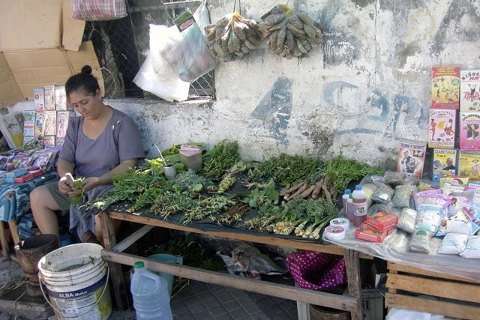
Mate Seller, Asuncion
Asuncion didn't leave much of a favourable impression on us. The capital city of Paraguay is run-down, decrepit, buildings falling apart, paint coming off, not much visible commerce, police and military everywhere, lots of statues and memorials to "heroes" etc., difficult to find a breakfast restaurant, couldn't find most of the sights in the guidebook. The city looked a bit like Rangoon (Burma) or Juba (Sudan). What is there to drive the economy? We were glad we hadn't checked in to stay overnight here. It soon got oppressively hot, all the more reason to get out of here.
Our bus to Encarnacion was on time at 12.00. Luckily it was air-conditioned, it was in the 30's C outside, the hottest I've seen on this trip. Scenery all afternoon was plain but pretty. Some hills and bush, but mostly flat farmland with lots of cattle and horses.
As we arrived in Encarnacion, in the east of the country, it was 19.00 and getting dark. This town is less decrepit and more quiet and laid back than Asunction. This would be a base to explore historical mission stations in the neighbourhood.
It had been a long day or 2, so we were tired. We found and checked into the Hotel Itapua, and found nearby restaurant for a good dinner. That was enough for the day. It was hot as blazes in the room, but I must have been tired because I slept well.
We have one full day to explore the sights around Encarnacion before my visa runs out. The relevant sights here are the ruins of the Jesuit missions. This whole area started off as a Jesuit republic in the 16 & 17th centuries before being taken over by other countries.
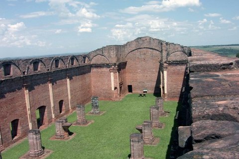
Jesus Mission
We found, in the bus station, a local bus around 09.00 to take us the 30 km or so to the Trinidad Mission, the first of two missions we'd see that day. This was the last, biggest and best preserved of the Jesuit missions. It consists of a large complex of sandstone foundations and walls of buildings covering a few hectares. It apparently has UNESCO designation.
From there it was another, smaller bus along back roads about 12 km to the Jesus Mission. This mission was smaller than the Trinidad one, but equally picturesque.
The whole countryside around here is quite pretty. Small roads, rolling hills, patchwork fields and a variety of crops, grass and trees give it a tranquil, bucolic feel. It made our brief time in Paraguay well worth it.
Back in Encarnacion about 14.00, we booked a bus to Ciudad del Este, the city on the border with Brazil at Iguasu, for 08.00 tomorrow. That would get us into Brazil at Iguasu Falls sometime tomorrow.
28 March, our third day in Paraguay, was the day I have to leave before my visa runs out. Our bus (a rough & ready local type) was on the road promptly at 08.00. It was a hot ride for 6 hours through big farm country, hills and some forest/jungle. We had lunch at the border city Ciuida del Este and changed our leftover Paraguay money. CdE is a typical third world border town; crowded, busy, grotty, full of shops and hawkers.
Brazil
(Click for map)We caught a local bus across to Foz d'Iguasu (Iguasu Falls, Brazil). There were too many vehicles waiting to cross the border. So we had to de-bus near the border, then walk along and across the bridge, and back onto another bus.
A taxi took us from Foz De Iguasu bus station to the YHA Paudimar Falls hostel. It's a nice place to stay; swimming pool, small restaurant, bar, friendly people, help to organise transport, etc.
Brazil is certainly in a different league to Paraguay. It's much cleaner, more developed and wealthier. Murderously hot though; about 37 deg at sundown. I'm surprised I could sleep OK.
We booked a day trip for tomorrow across to the Argentinian side of the Foz de Iguasu. It starts at 08.00 and goes to about 17.00.
We were ready for the tour to the Argentinian side of Iguazu Falls before 08.00 next morning, but weren't picked up till closer to 09.00. In a mini-bus we drove the few km to and through the border. We weren't stamped out of Brazil, but were stamped into Argentina for the day.
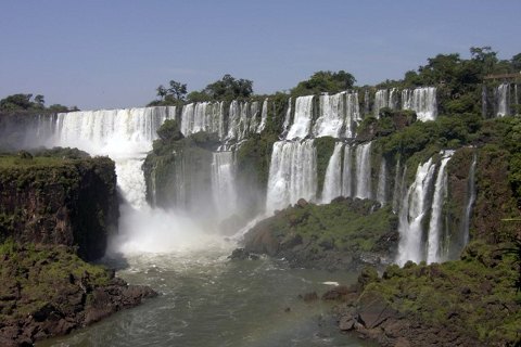
Iguasu Falls
On through tropical forest to the entrance to the falls. After looking around the facilities, We set out to explore the falls. There are a number of trails and options for getting about. The upper circuit is a walking track that goes past the tops of some of the cataracts. The lower circuit looks at the same cataracts from near the bottom. From the circuit you can walk down to the Iguasu River, take a boat across to an island in the river, and look around the bases of more of the falls. Then, at the top again, a small tourist train can take you to a walkway over the river to the Devils Throat, the upstream part of the falls. This series of cataracts is partly horseshoe shaped, and is the noisiest and most impressive part of all the falls.
The falls are certainly impressive, maybe rivalling Victoria Falls in Africa, but probably not as big. Butterflies are everywhere in great numbers and varieties. Some types land on our arms to suck the salt off our skin.
Back on the mini-bus at 17.00 to go back to Brazil. It was still diabolically hot, so just a quiet poolside evening.
Next day was mundane chores and a tour of Itapu Dam before boarding the night bus for Ilha de Santa Caterina and its capital city of Florianopolis.
Herbert needs to change more money, and I have to get rid of my last 30 Arp (changed to 21 Brl). So first thing to do after breakfast is to find a cambio. With difficulty we located one and did our transactions. The exchange rate is about 2.1 Brl to the USD. Then Herbert found a phone office to call Annie in France. I took the opportunity to phone Maggie for a few minutes too.
Then a local bus took us to the Iatapu dam north of town. This is said to be the world's biggest hydroelectric dam, generating electricity for Brazil and Paraguay, and an impressive tourist site.
We got to the dam place before 11.00, just after the last morning tour, and the next is 14.00. So we had to kill time by walking over to the nearby museum for an hour or so. It had exhibits of the history and anthropology of the area, construction and details of the dam, and ecological aspects; all good to pass the time.
The dam tour was free, starting with a film about construction, statistics and ecology etc. Then the group boarded buses for an hour's drive around and over the dam site. It was quite a huge and impressive structure, the whole dam covering several km including the rock/earth part, and a number of penstocks and generators. But the buses only stopped for 1 photo op, and we didn't get a look at all at the generators etc. So it was good/not-so-good.
The local bus took us on a cooks tour of city suburbs before dropping us near the hostel by late afternoon.
Back at the hostel we had one last swim in the hostel pool and a meal. I found, for just about the first time in South America, that I could get on-line wi-fi with my PDA. Wow! So I spent a couple of hours on my email and financial websites getting downloads and data.
We took a taxi to the Rodoviaria (bus place) by 19.30 or so to get on the bus at 20.00 for Florianopolis. We had an extremely hot and sticky wait for the bus (it feels like Cochin in India). But the bus left on time, and its air conditioning was heaven.
After a night travelling east through farmland and some bush (seems like there's no virgin jungle left), we came through Curtiba and on south into the daylight. Towns along this stretch seemed to have a lot of German influence. Across the bridge and to the island and city of Florianopolis by about 12.30.
From the bus place we walked the km or less to the youth hostel and checked in. It's an OK place but no pool like in the Foz one. In the afternoon we wandered around the down-town area, looking at some of the old buildings (not many of them), the market, and the mostly blocked off waterfront.
Back at the hostel I cleaned up and did laundry. Later I walked around the north waterfront/beach for a couple of hours in the evening. It was a somewhat swish area with lots of hotels, apartments, restaurants, a shopping centre etc. A big mechanical talking Easter bunny entertained hordes of kids in the courtyard.
April Fools Day, and we are to try our luck out on Santa Katerina's renowned beaches. If they're good we might stay here a while. We took our gear down to the island bus station and got on a bus for the north of the island. Then another bus took us to Ingleses Beach and Santinho Beach. The whole trip was maybe an hour.
At Santinho we started to wander to find accommodation. This seems like a modern resort area, quite built-up; no bamboo/thatch bungalows here. Exasperated with lack of success, we entered a local restaurant to ask around. No-one spoke English, and our Portuguese extended to maybe a couple of words. But we managed to make our needs known. A local guy offered to show us a place he had. It turned out to be a big 3-storey house, with 3 bathrooms, kitchen, dining, lounge, patio, 3 bedrooms, top floor with bed and terrace, etc. etc. Hard negotiation ended up getting us the place for 10 days for 500 Brl (that's about $US 12.00 per person per night). It's a lot more luxurious than we're accustomed to; damn, have to get used to it.
This part of the island is a chain of beaches stretching for most of the east coast. Our beach, Santinho, is maybe a couple of km long and good for surfing. 1.8 km north of us is Ingleses Beach, more built-up and less nice than ours, but calmer for swimming.
After settling in to our rooms and unpacking our gear, we set out to explore. There are a supermarket and internet place nearby. The beach is a couple hundred metres away. We walked to the north end of the beach, and across dunes and grass to Ingleses Beach, where we relaxed and swam a while. There are quite a few people around but not really crowded. Sea breezes kept everything wonderfully cool, refreshing after the last few days of 30's temperatures.
Back to our place we bought a dozen beer and nearly 100 Br worth of groceries. Using the kitchen, we cooked up a big feed of spaghetti bolognese for dinner; a nice change from bought meals.
In the evening we enjoyed the cool, breezy quiet, with the village lights and sound of the surf. This is heaven. Maybe 10 days here will be too much, but I don't think so. We've been rushing through so much lately that the break will be great.
The days 2 April to 10 April were all based in our house at Santinho Beach. We spent the whole time "on holiday". So don't expect a lot of activity, adventures, new discoveries or detail.
Ingleses Beach
We shopped daily in the local supermarkets, buying enough food for the day (maybe 20 to 40 Brl per day) and preparing or cooking our own great meals. We Probably ate far better and cheaper than by patronising local restaurants.
On a daily activity basis, Herbert would spend his time walking the beaches and surrounding areas, swimming and reading on the beach. I have a bit more of a restless streak in me, so besides swimming and lazing, I would spend comparatively more time on longer walks; through villages, over headlands, to farther beaches, up to summits of hills, across sand dunes, and whatever takes my direction.
A little about our environment. Ingleses and Santinho are beach/resort communities on the northern part of the east side of Ilha de Santa Caterina. Ingleses (named because there was once an English shipwreck here) is the bigger and more commercial beach/village to the north, separated from Santinho by a road (about 2 km walk), some small sand dunes, and by a big rocky bluff seaward. To the south, past another coastal bluff with a long waking path, is the long, beautiful, undeveloped and uncrowded Mocambique Beach. Behind everything, inland to the west, is a long stretch of sand dunes reaching all the way from Ingleses to Mocambique. West past the dunes are small subdivided farmland properties. The beaches, and dunes, are all a very fine white sand. Ingleses beach is most crowded, Santinho less, and Mocambique still less. All are good for swimming and Ingleses is great for people watching. The Girl from Ipanema had come down to Ingleses for my viewing pleasure, but of course she ignored me. Mocambique is an enormous beach, maybe 9 km long, and wonderfully undeveloped.
The only thing we haven't got is a TV with CNN or BBC, but I go down to the internet café every day or two to keep in touch with people or download news articles from websites.
Santinho Village
Agriculture seems to be a part of life here, at least with the ant population. If you look down at the path you're walking on, you can often see a column of leaves or bits of leaves moving along, carried by leaf-cutter ants. They take the leaves underground, and feed on the micro-organisms that grow on them.
11 April, and we'd been at Santinho 10 days, totally pleasurable and relaxing. We were expecting the house owner to show up at 09.00, but he didn't show. After some waiting and chasing around, we finally got him on the phone and he came around about 10.00. Because there were no buses running today for some reason, he volunteered to drive us in to Florianopolis; great.
Back in the city, we immediately checked out buses to Sao Paolo and Paraty, and booked a night bus to Sao Paolo for 6.55 pm tonight, about an 11 hour trip.
So we had nearly 8 hours to kill. We dropped our packs in day storage and spent most of the afternoon wandering around the city centre exploring and looking at shops etc. Unlike the last time we were here, on a Sunday, everything is now open and busy and full of life.
Our bus ride to SP was pretty routine, arriving at the Rodoviaria in the north of the city about 06.00. SP is just a big city so no point hanging around here. We immediately checked out a bus from Sao Paolo to Paraty, leaving at 08.00, a 5 or 6 hour trip.
The bus itself was ordinary, but the scenery from SP to Paraty was wonderfully beautiful and scenic, lots of hill and forest countryside and a few lakes. A long scenic descent got us to the coast, along which we went through numerous resort and beach communities all the way to Paraty.
At Paraty, we disembarked and walked the short distance to the Posta Familial, a good room in a nice little place run by a friendly Belgian guy.
Paraty
In the afternoon, after only a few minutes rest, we set out to explore the town. It's a small coastal community with a 19th century core several blocks square that has world heritage historical designation. The core streets, cobbled and chained off against vehicle traffic, abound with craft shops and restaurants. The buildings are colonial style, architecturally tasteful, nicely maintained and painted up in bright colours.There are also 4 historic churches, a pier with cruise boats and fishing boats, and beaches. The whole place has an attractive, relaxed atmosphere to it. Herbert ranked it even higher than Colonia in Uruguay.
In the evening we went out in search of food, and ended up at a relatively expensive "Italian" place where we had beer and spaghetti. A slow walk back home took us past lots of street vendors and shops selling crafts, and an ice-cream place where I indulged a little.
It was warm out but not oppressively hot; I managed not to be sticky-sweaty all day.
The breakfast in the hostal is good, lots of bread, butter, cheese, jam, juice and tea or coffee.
We have a couple of days more here in Paraty, to do light sightseeing and easy things. We checked bus information to go to Rio, then more sightseeing around town and a walk outside of town and up the hill to the remains of a Portuguese fort overlooking the bay. There wasn't a lot of interest in the fort, just some very low walls and a few rusty cannon, but of course good views. Back at the bottom, I spent an hour or two at the small beach on the edge of town. They were pleasant enough but nothing like the Santa Caterina beaches.
I continued walking around the south part of town, slightly grubby and industrial, with lots of fishing boats and residential areas. Caught in a rainstorm for a while, I sheltered under a roof overlooking the river. Then back down-town and home via the small airport.
Dinner in evening was at a pay-by-weight buffet, beef stew and lots of other things. PBW seems a fairly economical way to eat; substantial and not expensive.
Next day we bought bus tickets to Rio for 09.00 tomorrow. Herbert decided to go on a 5 hour boat tour to nearby islands etc. I chose to take a walk inland along country roads.
From the town, I walked past the main highway onto a small road past fields, houses, guest-houses, hills and bush. It was 5 km to the Fazenda Murycana Cane farm, a colonial-era farm where now they grow cane, make the catchaca cane liquor, and cater to tourists. I spent an enjoyable hour there looking around the museum-type exhibits and sampling their coffee and their trademark potent cane spirit.
From the farm, it was another km or so along forest roads to a couple of waterfalls, good for refreshing swims. Back to town by about 14.30, it was quite hot and I'd had enough walking. While out for my evening meal, it started to hose down rain; quite a sight with streets flooding and people and cars splashing through. As soon as the rain eased and I could move, I went over to a small bar for a cold beer and a little more people watching.
15 April, we're on to our final destination today. After breakfast we said our adieus to Joseph (it was a nice place we stayed at) and made our way down to the bus. It left at 09.00 on the dot.
In brilliant sun, we passed more beautiful scenery; forest, coast and beach communities, on the way to Rio. Through suburbs and an industrial/wharf area, we got into the Rio de Janiero Rodoviaria about 13.00.
On New Years Day 1502 the Portuguese Navigator Goncalo Coelho arrived at this area. He thought it was mouth of a great river (it wasn't) and, being the month of January, that's where it got its name.
In the bus station, we found a very friendly and helpful tourist office. The girl told us about accommodation and lined us up with the Sun Beach Hostel on Santa Clara in Copacabana. A taxi took us there in 1/2 hour and we checked into a small double room with bunk beds. The hostel had a kitchen, TV, lounge room, internet etc., about 4 blocks from Copacabana Beach. We'd be here for 4 or 5 days before Herbert and I had to fly back to our respective homes.
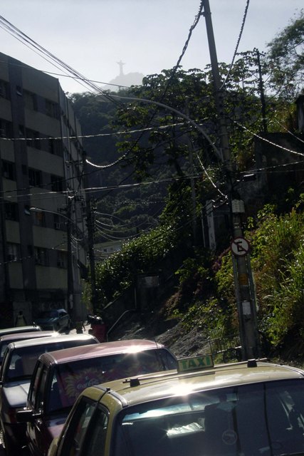
Flavela with Corcovado in background, Rio
After settling in, we walked to the beach to check out the Sunday crowds. It certainly had a crowd; the long wide beach had tens of thousands of people on it, a forest of umbrellas near the water, a multitude of beach-volleyball courts nearer the road, and the water full of people.
Copacabana is not as upmarket as I expected. The frontage is lined with mass-market high-rise apartment towers, all a little dated, some even seedy, looking.
Next day we start to explore Rio de Janeiro in earnest. A short walk down the street took us to a metro station, where we got return tickets to the Centro. The metro was quick and easy, dropping us in the Centro area in about a quarter hour. First task was to find the airline offices and confirm our respective flights, also quick and easy.
The next hour or two, we did a self-guided walking tour of parts of the Centro district. It took in some main streets and historic buildings and churches, parks and plazas with the usual heroic statues of great men on horses (Well hey, he must be great, he has a horse under him!), and narrow streets with crowded knick-knack markets. One small park was interesting in that it had lots of wild (?) guinea pigs running around underfoot.
All-in-all, Rio Centro didn't have a lot distinctive or exciting about it; not a great place. The city is noted for it's natural features, like the Corcovado, Sugarloaf, beaches etc. rather than man-made things.
From down-town, we made our way over to the ferry dock to find a ferry to Niteroi Island. The island communities are thought to be more like the rest of Brazil than Rio is. The quarter hour ferry trip was nice, offering pretty views over the city, surrounding hills, Corcovado and Sugarloaf. Aside from markets, souvenir stands and restaurants, Niteroi city was nothing special, maybe because we'd seen other Brazilian cities already.
Back in the city, we walked down to the rather drab looking Flamengo Park along the waterfront, and got a train back to Copacabana. After lunch we walked down to Ipanema to look at Ipanema and Arpoador Beaches and the rocky Ponta Arpoador. Ipanema didn't seem a lot different to Copacabana, maybe a bit more upmarket in places. Where's the Girl? Oh yeah, she must still be down at Ingleses Beach. A bit of a swim and laze around, and slowly back home.
On our third day the Corcovado was in cloud, so no point going up there at the moment. We started about 09.30 to do a long slow walk to and along Ipanema Beach, then inland to Lagoa Rodrigo de Freitas (a rather built-up and unimpressive lake), and around to Jardim Botanico.
The botanical gardens, in the south of the city tucked with the lake behind Copacabana and Ipanema, is a pleasant garden, its main claims to fame seem to be its rows of 30 m high imperial palms (not native to the area though) and the pond with the giant (at least a metre wide; I was impressed) water lilies. We wandered through the orchid greenhouse; I always like looking at orchids, such a rich and fascinating variety of plants.
Back via Leblon (the beach just to the right of Ipanema), we stopped for a rest at Ipanema Beach, and continued back to Copacabana where we had a big fish lunch at the usual restaurant.
The fourth day in Rio, it's now or never to try the Corcovado. It looked sunny out, so down to Avenida Nossa Senhora Copacabana to catch the 583 bus to Cosme Velho at the bottom of the mountain.
Suzie in the hostel had advised us that a rail car up to the Corcovado costs 35 Brl each, plus 5 Brl park entry. But we should be able to get a taxi up there for 50 (plus entry fee). It's a good thing she told us that; when we got off the bus, a rough-looking tout came to us and tried to sell us a taxi ride for 35 each, same as the train; no thanks. We walked around until we found a taxi that would take us for 50. As we drove past the mafioso, he was shouting at the taxi driver for undercutting his business. I hope our driver didn't later end up in cement overshoes.
It's a fair distance up along a steep winding road through tropical forest to the 704 m high Corcovado.
We passed the monument entrance where we paid the entry fee, and then up to the crowded little car park. The taxi guy gave us 30 minutes here. Up we walked several flights of stairs, past the ubiquitous souvenir shops and restaurants, to the statue itself. The Monumento do Cristo Redentor Corcovado, Christ the Redeemer, is 30 m high with an 8 m pedestal, and of course is the symbol of Rio. It does look quite large and impressive up close. The sun was out, with a bit of cloud on one side of the mountain, so there were panoramic views over Rio in all directions. It was quite hazy below though, so a bit hard to see detail.
We absolutely refused to take our pictures in front of the statue with arms outstretched, like everyone else was doing.
Back down at the bottom, it seems we've seen everything worth seeing in this city. A similar trip (cablecar) up Sugarloaf could be done, but wouldn't be anything significantly different. So on the bus and back to the hostel by noon or so, for a day of beach relaxing.
Herbert leaves tomorrow, and myself the day after. So in the evening, as a last meal and celebration, we wandered over to the Monchique Churrascaria restaurant for an all-you-can-eat buffet and barbecue meal. The place was recommended by the hostel, with good reason. It was very reasonably priced and an amazing variety of very good foods. The barbecued meats, including the "picanya" skewered roasts, were to die for. They just kept pouring it on, coming back to the table to give us more meat, and it was too good to refuse. And I maybe almost did die for it too; eating so much that I seemed to have my first ever "food hangover" that night and next morning. The whole meal, including two beer each, cost about 49 Brl for the two of us, about USD 24.
19 April is Herbert's last morning, he goes to the airport about 11.00. We walked over to a nearby shopping centre, where Herbert looked at antique stores and I got onto internet for an hour. Then our goodbyes and Herbert was off by bus to the airport.
In the afternoon, with not a lot better to do, I got on the metro and went down to the centro to do some general wandering and exploration. I got off the train near the Maracana Soccer Stadium, at 100000 capacity, maybe the world's biggest. Yes, it did look big. Yes, they do love their soccer here.
From there, I found my way across the motorway to a big park that housed the zoo and national museum (under restoration). It wasn't that impressive a park, so I continued walking back toward the Centro. As we noticed before, there wasn't a lot exciting or distinctive about the city.
I looked around again at the busy and colourful market streets near Presidente Vargas, then along P V Avenue to the big church called Igregia da Candelaria. As I was photographing the church an amazing thing happened. After 3 months travel here, on virtually the last day of my trip, my 4-year old digital camera packed it in, refusing to turn off or respond to commands. What timing!
A bit more of a wander to Praca 15 de Novembro, and I boarded the fairly crowded metro about 18.00 for the trip back to Copacabana.
20 Apr was my last day here in South America. Just time for last emails/internet, final packing and organising, check out of the hostel, spend a couple of hours on Copacabana Beach, change back my residual Brl to USD, and get down to the airport bus.
My plane was scheduled to leave at 20.45, and I should be there 2 hours ahead. The hostel advised that the bus runs every half hour and could take about 1.5 hours to the airport. So I was down waiting for the bus about 16.45.
The advice wasn't that great. I waited about 55 minutes before the bus finally crawled by. Then it continued at the same slow/stop pace all the way to and through down-town and out north-west toward the airport. It was a Friday evening on allegedly a long weekend, and the whole of the city was a parking lot. Finally, sometime after 19.00, one of the passengers went up to talk to the driver, and got the impression we weren't going to get to the airport any time soon. He had to fly before 20.00. So eventually he, myself and a couple of other passengers teamed up to abandon the bus and see if a taxi would have any better luck.
We got into a taxi and negotiated a price. The taxi was able to weave through traffic easier and got us the final 30 km or so by about 19.40. I rushed straight to check-in, answered security questions, got my boarding passes, waited in line more for security, and onto the plane with maybe 15 minutes to spare. Was that tight or what?
From then on, the plane flights were blissfully uneventful and on-time. I met Maggie at Winnipeg airport at 17.45 on April 21.
It was a good trip for 3 months in South America. We saw a lot, had a great time, and expenses were well within my budgeted figure. I regret not making it to the south of Chile and Argentina, maybe another time for that. Anyway, it's great to be back in Canada with Maggie.
My favourite country in SA? Probably Bolivia; it was one of the poorest and most undeveloped. But it had some of the most unusual and spectacular sights and activities of all. The rugged and scenic south and south-west of Bolivia were truly amazing.
Next trip? Probably Europe by rail-pass later this year. Check it out.